Winter storm watch canceled for southern Wisconsin as storm takes major turn to the south; little to no snow expected
 Joe Taschler
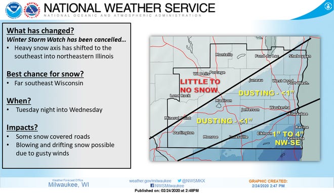
Forecasters have canceled the winter storm watch that had been in effect for southern Wisconsin after the storm took a southward turn overnight and kept heading south during the day Monday.

Far southern Wisconsin, including Racine and Kenosha, might see a couple of inches of snow. Most everywhere else in southern Wisconsin is expected to see only a trace, if any, snow.
It is unlikely, given the latest forecast information, that the storm would swing back to the north and bring significant snow to southern Wisconsin, said Aidan Kuroski, a meteorologist at the National Weather Service in Sullivan.
"The system has really, really shifted to the south," Kuroski said. "We expect any further changes will continue to be further to the south rather than to the north."
If you have travel plans in the Chicago area, you'll want to check the forecast for that region.
"Northeastern Illinois is still going to get hit pretty hard, but it's shifted southward enough where we're just not going to see that much across southern Wisconsin," Kuroski said.
Forecasters issued the winter storm watch based on what computer forecast models were saying about the storm.
On Sunday, those forecast models were indicating that at least 8 inches of snow could fall across southern Wisconsin, and that was on the low end of the predictions, Kuroski said.
Then the storm veered south and forecasters only had to cancel the winter storm watch — as opposed to a warning or advisory having to be canceled once the snow began — or didn't begin — to fall.
"It's something that does happen every year with a (winter) storm or two," Kuroski said. "Lately, the models have been not so great with these last two systems."
Contact Joe Taschler at (414) 224-2554 or jtaschler@gannett.com. Follow him on Twitter at @JoeTaschler or Facebook at facebook.com/joe.taschler.1.